$85.00 CAD
– Sold Out| /
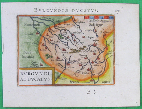
Originale carte,gravure de cuivre colorée, par Abraham Ortelius de l'Atlas de poche:'Épitome theatri Orteliani. Nova Editio.' publié en Latin, Anvers Belgique 1595.
Impression forte, légèrement brunâtre et colorées, petites restaurations.
11 x 15 cm
.
Original and hand-coloured copper engraving map by Abraham Ortelius, from his pocket Atlas: 'Epitome theatri Orteliani. Nova editio.' published in Latin, Antwerp Belgium 1595.
Strong print, great colour, marginal browning and staining, small restorations.
11 x 15 cm
Abraham Ortell [Ortel, Ortels, Ortelius], né à Anvers, 1527 - 1598, est un cartographe néerlandais (Dix-Sept Provinces)
Le Theatrum Orbis Terrarum sortit de presse, le 20 mai 1570, imprimé aux frais de l'auteur, chez Gilles Coppens, à Anvers. L'ouvrage était dédié au roi Philippe II d'Espagne, et comptait 53 cartes. Ce livre, qui avait demandé plusieurs années d'un travail intensif, répondait à un besoin public. Il connut, dès son apparition, un succès prodigieux. La première édition fut rapidement épuisée et, la même année, paraissait une deuxième édition latine. En 1571, une troisième édition latine et une édition flamande ; l'année suivante, une édition allemande et une édition française.
Abraham Ortelius (also Ortels, Orthellius, Wortels; 1527 – 1598) was a Flemish cartographer and geographer, conventionally recognized as the creator of the first modern atlas, the Theatrum Orbis Terrarum (Theatre of the World). He is also believed to be the first person to imagine that the continents were joined together before drifting to their present positions.
In 1564 he published his first map, Typus Orbis Terrarum, an eight-leaved wall map of the world, on which he identified the Regio Patalis with Locach as a northward extension of the Terra Australis, reaching as far as New Guinea. This map subsequently appeared in reduced form in the Terrarum (the only extant copy is in now at Basel University Library). He also published a two-sheet map of Egypt in 1565, a plan of the Brittenburg castle on the coast of the Netherlands in 1568, an eight-sheet map of Asia in 1567, and a six-sheet map of Spain before the appearance of his atlas. In 1578 he laid the basis of a critical treatment of ancient geography by his Synonymia geographica (issued by the Plantin press at Antwerp and republished in expanded form as Thesaurus geographicus in 1587 and again expanded in 1596. In this last edition, Ortelius considers the possibility of continental drift, a hypothesis proved correct only centuries later).
Source: Wikipedia